


Etang de Lers

josy31
User
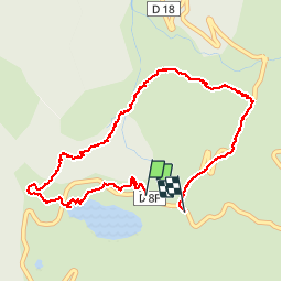

Length
5.1 km

Max alt
1304 m

Uphill gradient
185 m
Km-Effort
7.5 km

Min alt
1125 m

Downhill gradient
185 m
Boucle
No
Creation date :
2014-12-10 00:00:00.0
Updated on :
2014-12-10 00:00:00.0
2h15
Difficulty : Unknown

FREE GPS app for hiking
 SityTrail
IGN / Geographical institutes
SityTrail Plus
The world is yours!
About
Trail Walking of 5.1 km to be discovered at Occitania, Ariège, Le Port. This trail is proposed by josy31.
Description
Sympa à faire avec des enfants
Positioning
Country:
France
Region :
Occitania
Department/Province :
Ariège
Municipality :
Le Port
Location:
Unknown
Start:(Dec)
Start:(UTM)
367603 ; 4740861 (31T) N.
Comments